| ©
Karin Herrero |
|
 |
|
 |
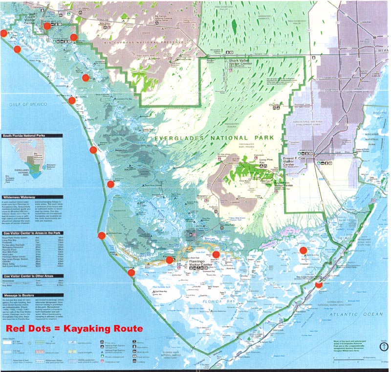
My husband Jake and I flew from
Calgary, Alberta, Canada, to Miami, where we took a shuttle van
to Key Largo, the starting point of our kayak trip, about 90 km
directly south of Miami and less than 2 km east of the Park
boundary. We had bought a 17 foot double folding kayak, sight
unseen, from a U.S. manufacturer, had it shipped to our hotel in
Key Largo, assembled it there, and launched it right from the
hotel’s beach into Florida Bay.
It was the beginning of December and we
had a total of 19 days at our disposal. While winter was
tightening its grip on most of Canada and the northern United
States, here in South Florida a cold front had moderated the
heat and humidity and promised predictable northerly winds and
clear skies.
At a paddling store in Key Largo we
purchased final provisions, including nautical charts and a
guide book, and then sketched our route: across Florida Bay to
Flamingo, where we would re-supply and extend our backcountry
permit, then westwards into the Gulf of Mexico, rounding Cape
Sable and following the coastline north. At the mouth of the
Chatham River we would head inland and follow various waterways
until we reached Everglades City. There, we would re-supply
again and, time permitting, continue paddling further north. We
had heard about the Wilderness Waterway (WW), the Park’s
premier route (a 160 km long inland route from Flamingo to
Everglades City), but decided to paddle the coast. This, after
we learnt that the coast offers more chances for solitude (Jake
came up with the name "Wilderness Motorway" after
reading in A Paddler’s Guide to Everglades National Park
that the WW is not the route to take if you want to avoid
motorboat traffic), less insects, and more ground to stretch
your legs. However, we were open to the option to turn inland
should the weather turn rough.
|
 |
|
 Loaded
with camping gear, freshwater, and home-cooked, dried food, we
launch the kayak into Florida Bay. Our plan is to paddle to
North Nest Key, a mangrove-covered island with small beaches,
where camping is permitted. This 12 km long trip is our practice
round to check the new boat’s (and crew’s) performance and
see if both are up to the following day’s 32 km paddle to
Shark Point (no other official campsites along the way). Soon,
we’re moving through sage-green waters, rippled by a light NE
breeze. Although the sky is streaked with white clouds, the
sunlight is intense and we get out our hats and sunscreen. Loaded
with camping gear, freshwater, and home-cooked, dried food, we
launch the kayak into Florida Bay. Our plan is to paddle to
North Nest Key, a mangrove-covered island with small beaches,
where camping is permitted. This 12 km long trip is our practice
round to check the new boat’s (and crew’s) performance and
see if both are up to the following day’s 32 km paddle to
Shark Point (no other official campsites along the way). Soon,
we’re moving through sage-green waters, rippled by a light NE
breeze. Although the sky is streaked with white clouds, the
sunlight is intense and we get out our hats and sunscreen.
After less than an hour, we encounter
our first mangrove islands: two low mounds topped with a
thick-leafed canopy, sitting on a base of an impenetrable mesh
of twisted, partially submerged roots. Jake spots a narrow
passage between them and we glide into calm waters, our paddles
and shoulders brushing against the branches. Within minutes, we’re
through and head towards two larger islands. On the calm lee
side of the second island, we stop for a quick snack break. The
heavily wooded keys don’t allow for a landing, but in shallow
Florida Bay it’s not a problem if you really want to stretch
your legs. In many places you can get out of the boat and stand
in knee-deep water.
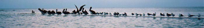
Depth marks on the Florida Bay nautical
charts hardly ever exceed nine feet, and here in the eastern
part of the bay they range from one to seven feet. For the next
three days we would often see birds standing in the water, miles
from shore, and we’d encounter many marked channels, which
were dredged to allow passage for larger boats.
In the early afternoon we arrive at
North Nest Key, tie the kayak to the dock and walk the small,
sandy beach. After setting up camp, we practice a self-rescue in
the warm, shallow waters off the beach. It takes a lot of
concerted effort to purposefully capsize the kayak, and we’re
comforted by the remarkable stability of the boat. Folding
kayaks are extremely sea worthy, due to their ability to flex
slightly in the waves.
With the sunset arrive tiny no-see-ums.
We cook on the dock where there is a bit of a breeze to keep the
insects at bay, then carry the boat on to the beach and pre-pack
most of our gear for an early start the next day. By 7 p.m. we’re
in the tent, listening to the concert of crickets and to the
water gently lapping at the shoreline three feet from us.
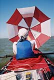
Before sunrise, we break camp, eat a
quick breakfast and start paddling as soon as there is
sufficient light. An overcast sky provides relief from the
intense sun. Encouraged by a NE wind we hoist our red and
white-striped golf umbrella, (about three times the size of a
regular umbrella) and sail westwards, passing numerous
mangrove-covered keys. It’s Saturday and the increased
motorboat traffic is noticeable. Motorboats pass us (most of
them politely throttle their engine when passing). In one of the
channels, we surprise a couple in a motorboat as we quietly
glide by with our unusual ‘sail’. "Where do YOU come
from?" the man asks surprised. Since our boat only needs
four inches of water, we occasionally take shortcuts across the
mouth of shallow bays (something a motorboat crew wouldn’t
do), brushing sea-weeds and touching the bottom with our
paddles.
|
 |
|
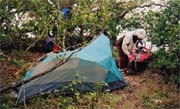 By
3 p.m., as the sunlight begins to soften, we hug the shore and
search for the entrance to the campsite at Shark Point. But
there seems to be no break in the mangrove. Jake pulls out his
GPS and checks our location. And then we see it: a tiny break in
the jungle, a "beach" barely wide enough to pull one
or two boats in. As soon as the bow touches the ground, I jump
out of my seat, pull the bow higher onto the beach and race into
the bushes to relieve myself. Immediately, a cloud of mosquitoes
surrounds me and I hurry back to the boat to put on my bug shirt
and long pants. We haul the boat out and carry it over black mud
and dead vegetation to a small level spot in the thicket, where
we pitch the tent and dive into it to escape the bugs. Although
there is a larger clearing beyond the mangroves, the insects are
even fiercer there. We wonder why this place is used as a
campsite. Later on our trip we come to realize that high, dry
firm ground suitable for camping is scarce in the Everglades,
where the high point is eight feet above sea level. With sunset
the jungle comes alive. Crickets and frogs join in the mosquito
concert, fish and shore birds splash at the water’s edge,
something whizzes through the trees (a bat? a hummingbird?), and
the tiny sparks of fireflies dance in the darkness. After we’ve
eaten dinner inside the tent, I brave the bugs once more to
clean up the dishes and hang the food bags from branches to keep
them away from small critters. We’re tired, but happy to have
made it here all the way. By
3 p.m., as the sunlight begins to soften, we hug the shore and
search for the entrance to the campsite at Shark Point. But
there seems to be no break in the mangrove. Jake pulls out his
GPS and checks our location. And then we see it: a tiny break in
the jungle, a "beach" barely wide enough to pull one
or two boats in. As soon as the bow touches the ground, I jump
out of my seat, pull the bow higher onto the beach and race into
the bushes to relieve myself. Immediately, a cloud of mosquitoes
surrounds me and I hurry back to the boat to put on my bug shirt
and long pants. We haul the boat out and carry it over black mud
and dead vegetation to a small level spot in the thicket, where
we pitch the tent and dive into it to escape the bugs. Although
there is a larger clearing beyond the mangroves, the insects are
even fiercer there. We wonder why this place is used as a
campsite. Later on our trip we come to realize that high, dry
firm ground suitable for camping is scarce in the Everglades,
where the high point is eight feet above sea level. With sunset
the jungle comes alive. Crickets and frogs join in the mosquito
concert, fish and shore birds splash at the water’s edge,
something whizzes through the trees (a bat? a hummingbird?), and
the tiny sparks of fireflies dance in the darkness. After we’ve
eaten dinner inside the tent, I brave the bugs once more to
clean up the dishes and hang the food bags from branches to keep
them away from small critters. We’re tired, but happy to have
made it here all the way.
With the morning the NE wind returns,
but the mosquitoes are undaunted and we can’t wait until we
make our escape. Once we’re underway, we hoist the umbrella
again and sail across Snake Bight, a large, shallow bay, where
most motorboats don’t venture. In some areas, the water is
only a paddle blade deep.
As we approach the settlement of
Flamingo in the early afternoon, we realize there is no beach
where paddlers can pull up their boats. Instead, there is a
marina with docks. Luckily, the staff of a canoe rental business
allow us to temporarily tie our kayak to the end of their dock.
Feeling that it is reasonably safe here, we leave the boat and
walk to the Park’s Visitor Center, where we extend our
backcountry permit after treating ourselves to calamari and
hamburger in the adjacent restaurant. Sitting at a window in the
air-conditioned dining room, we get a tourist’s perspective of
the Everglades. In the bathroom, I relish in the feeling of soft
water running over my salt-dried hands.
With 10+ days’ supply of freshwater,
and a copy of Peter Matthiessen’s book Killing Mr. Watson
(in the evenings we would read to each other from this novel,
which is based on the life of the notorious Ed Watson who lived
in the Everglades for over 20 years until he was lynched in
1910), we are ready for the longest portion of our trip.
However, it’s already 4 p.m., sunset is only 1 ½ hours away
and we still have to paddle about 6 km to Clubhouse Beach, the
next backcountry campsite. I am not happy about this, but Jake
has a point: staying at Flamingo Lodge, the only hotel here,
would cut a big hole into our limited budget, and, where would
we leave the kayak?
Paddling westwards into a golden
sunset, we pass a large grassy area near the shore: a private
campground. We decide to try our luck here. The camping area is
on raised earth, about two feet above the water. We unload the
kayak in shallow water and then keep it afloat with the bowline
tied to a picnic table and another line tied to a clump of
mangroves. Like our neighbors, we quickly escape from the
mosquitoes into our tent. Mercifully, at 8 p.m. a cool north
wind starts blowing and disperses them. But a pesky raccoon
keeps us on our toes throughout the night. In the morning, we
find muddy footprints on the hull and notice teeth marks on our
lunch box, which was stored inside the cockpit.
|
|
 |
|
|
 |
|
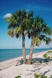
Our route now takes us around Cape
Sable, the most southerly tip of land in the mainland U.S.,
where the mangroves give way to long, shell-laden beaches backed
by coastal prairie dotted with cactus, agave and palm trees.
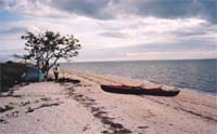
 For
the next three days we enjoy superb beach-camping including
campfires and beach walks, paddling with dolphins, and beautiful
sunsets as we have unobstructed views westwards across the open
Gulf. Even the insects have lost their fierceness, the motorboat
traffic diminishes, rain-threatening clouds pass overhead with
barely a drop falling, and the raccoons are content with what
the sea provides at low tide. We spend two nights at East Cape
and then paddle about 15 km to Northwest Cape. On the way we
round Middle Cape, once the site of Fort Cross, established in
the 1850s as a base for U.S. soldiers attempting to eradicate
the Seminoles Indians far back in the Glades. But now, there is
nothing left of it. Then we pass the Middle Cape Canal, which
connects Lake Ingraham with the Gulf. Warned about the strong
tides at the mouth of the canal, we make sure we cross it during
slack water. For
the next three days we enjoy superb beach-camping including
campfires and beach walks, paddling with dolphins, and beautiful
sunsets as we have unobstructed views westwards across the open
Gulf. Even the insects have lost their fierceness, the motorboat
traffic diminishes, rain-threatening clouds pass overhead with
barely a drop falling, and the raccoons are content with what
the sea provides at low tide. We spend two nights at East Cape
and then paddle about 15 km to Northwest Cape. On the way we
round Middle Cape, once the site of Fort Cross, established in
the 1850s as a base for U.S. soldiers attempting to eradicate
the Seminoles Indians far back in the Glades. But now, there is
nothing left of it. Then we pass the Middle Cape Canal, which
connects Lake Ingraham with the Gulf. Warned about the strong
tides at the mouth of the canal, we make sure we cross it during
slack water.
 Shortly after landing at Northwest
Cape, we spot a lone paddler on the glittering sea, heading
south. He lands his small craft close to our boat and we chat
like most people do when they meet on the trail. Siggy, a
Polish-American living in New York, tells us he’s on a
four-day loop trip out of Flamingo, where he first followed the
inland waterways to Oyster Bay, and now he’s returning via the
"outside". His craft is small and his provisions are
limited (he’s living on a daily water supply of 1.5 litres).
He admits he’s never traveled the open ocean before. I admire
his courage. We think we’ve found a neighbor, but he announces
he’ll camp further south and takes off again. Since rounding
East Cape in the morning, we have been paddling into a steady
NE/NW wind. Jake muses that without an umbrella, Siggy has
missed out on some great sailing. Shortly after landing at Northwest
Cape, we spot a lone paddler on the glittering sea, heading
south. He lands his small craft close to our boat and we chat
like most people do when they meet on the trail. Siggy, a
Polish-American living in New York, tells us he’s on a
four-day loop trip out of Flamingo, where he first followed the
inland waterways to Oyster Bay, and now he’s returning via the
"outside". His craft is small and his provisions are
limited (he’s living on a daily water supply of 1.5 litres).
He admits he’s never traveled the open ocean before. I admire
his courage. We think we’ve found a neighbor, but he announces
he’ll camp further south and takes off again. Since rounding
East Cape in the morning, we have been paddling into a steady
NE/NW wind. Jake muses that without an umbrella, Siggy has
missed out on some great sailing.
| Click
here to continue the journey... |
|
