| ©
Karin Herrero |
|
 |
|
|
 |
|
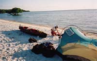
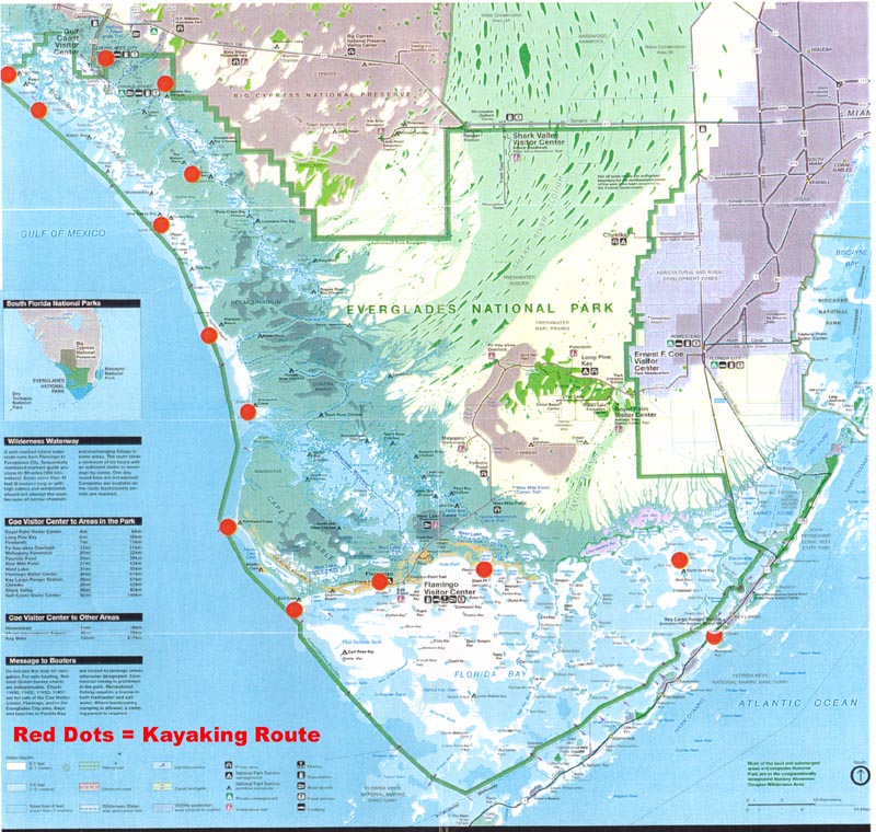
After four hours of paddling calm
rivers, bays and creeks, and spotting one alligator and several
dolphins along the way, we arrive at Sunday Bay Chickee, a
raised platform campsite on the north edge of a small bay that
splinters off from Sunday Bay. Although we don’t have a
reservation for this site, it looks so inviting that we decide
to hang out here until sunset, and, if nobody should arrive, we
would stay for the night.
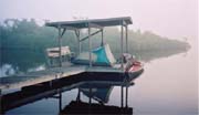
The chickee is an invention of the
Glades Indians. They built these open raised platforms with
palmetto-thatched roofs on beaches, along rivers, or over
sheltered waters. The well-ventilated dwellings, a healthy dose
of fish oil smeared on skin, and smoldering fires helped to keep
the mosquitoes at bay.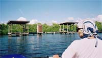
Sunset and we have Sunday Bay Chickee
all to ourselves. We relax on the sun-warmed bench and watch the
birds, jumping fish, and clouds. The insects are manageable and,
because we’re tucked behind a tiny island, we are out of sight
from passing motorboats less than a kilometre away on the
Wilderness Waterway.
The next morning is misty and calm. We
leave Sunday Bay Chickee and make our way back to the coast to
Everglades City, taking the Hurddles Creek and Turner River
Route. It’s relaxing not to have to worry about wind and
waves, but careful navigation is required around the oyster bars
at the mouth of the Turner River. Another challenge awaits us at
the entrance to Chokoloskee Bay where the outgoing tide almost
leaves us stranded in the shallows. After some panicky moments
we find a narrow channel with enough water, paddle under a
bridge and head for the Park’s Office with its tall flagpole.
But where can we land? No beach is in
sight. We paddle into a marina and tie the boat to a dock in
front of the Park’s building. While Jake seeks information at
the Park’s office, I babysit the boat and watch immaculately
dressed tourists strolling on the pier. Finally, Jake returns
with the message that we have to backtrack under the bridge to
enter a channel leading to the privately owned Glades Haven
Marina and campground. After some more anxious moments in the
fast-draining bay, we do make it into the marina and pull the
boat ashore at a slimy boat ramp. From there, we have to carry
it several hundred metres to a grassy spot assigned to us
between the motorhomes and trailers. It’s a far cry from our
quiet beach campsites, and we get scared by a pickup truck
spraying the area with insecticide after sunset, but a
consolation are the hot showers and a Laundromat.
|
 |
|
 |
In Everglades City we just stay long
enough to get clean, buy a few more supplies and extend our
backcountry permit. The next morning we paddle west, across
Chokoloskee Bay, then follow Sandfly Pass, a passage between the
islands leading to the Gulf. Before noon we arrive at our
destination for the day, Kingston Key, which is almost pinched
off in its middle section. The campsite here is a chickee,
sitting in a lagoon. The chickee was once a dock, but the island
shifted, disconnecting the dock. The Parks service then added a
camping platform. Since it is early in the day and low tide, we
decide to visit the beach that connects the two sections of the
island.
 We spend the afternoon lazing about, swimming, and
watching the dolphins chasing fish. When the beach starts
shrinking due to the incoming tide, we paddle over to the
chickee. Now, the water is just below the platform and it’s
easy to unload the boat, but we’re concerned to leave the boat
in the water during the night. At Sunday Bay Chickee, Jake had
protected the boat from the barnacle- and oyster-encrusted
pilings by tying it to paddles stuck into the muddy bottom.
Here, with the more pronounced tide differences and bigger wave
action, we are not satisfied with this solution and haul the
kayak out of the water. This proves wise since the wind picks up
at night. Once I wake and hear the water loudly slapping at the
pilings. In the morning we set the boat in the water before the
water level drops too low. By the time we are ready to load the
boat, we have to climb down the ladder to reach the cockpit. The
day is clear and sunny again. To wait for higher water we head
back to the same beach. In the afternoon, three kayakers and two
canoeists arrive. The kayakers, staff of a Virginia-based kayak
touring company, are on a day-trip. "Are you out for the
weekend?" one of the paddlers asks. Jake mentions that we’re
on a "multi-day" trip out of Key Largo. "That’s
a trip I’ve been hoping to do for some time," says the
kayaker. By 2 p.m. we leave the beach, and paddle northwards to
Tiger Key, the most northerly of all the campsites in the Park.
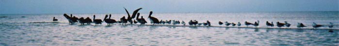
On our way we pass Indian Key, with hundreds of white pelicans
on its sandspit, and then Picnic Key, where we see several tents
along the beach. However, our destination, Tiger Key, has a
shallow approach, so we have this beach all to ourselves. From
here we have an unobstructed view of the open Gulf and get
treated to an orange and golden sunset, followed by no-see-ums
and a park ranger in his flat-bottomed boat, who checks our
permits. He expresses his admiration for our undertaking, but
doesn’t stay long because of the insects. Since we will be
leaving the National Park the next day, we ask him about camping
possibilities further north, but unfortunately, he can’t give
us much information. We spend the afternoon lazing about, swimming, and
watching the dolphins chasing fish. When the beach starts
shrinking due to the incoming tide, we paddle over to the
chickee. Now, the water is just below the platform and it’s
easy to unload the boat, but we’re concerned to leave the boat
in the water during the night. At Sunday Bay Chickee, Jake had
protected the boat from the barnacle- and oyster-encrusted
pilings by tying it to paddles stuck into the muddy bottom.
Here, with the more pronounced tide differences and bigger wave
action, we are not satisfied with this solution and haul the
kayak out of the water. This proves wise since the wind picks up
at night. Once I wake and hear the water loudly slapping at the
pilings. In the morning we set the boat in the water before the
water level drops too low. By the time we are ready to load the
boat, we have to climb down the ladder to reach the cockpit. The
day is clear and sunny again. To wait for higher water we head
back to the same beach. In the afternoon, three kayakers and two
canoeists arrive. The kayakers, staff of a Virginia-based kayak
touring company, are on a day-trip. "Are you out for the
weekend?" one of the paddlers asks. Jake mentions that we’re
on a "multi-day" trip out of Key Largo. "That’s
a trip I’ve been hoping to do for some time," says the
kayaker. By 2 p.m. we leave the beach, and paddle northwards to
Tiger Key, the most northerly of all the campsites in the Park.
On our way we pass Indian Key, with hundreds of white pelicans
on its sandspit, and then Picnic Key, where we see several tents
along the beach. However, our destination, Tiger Key, has a
shallow approach, so we have this beach all to ourselves. From
here we have an unobstructed view of the open Gulf and get
treated to an orange and golden sunset, followed by no-see-ums
and a park ranger in his flat-bottomed boat, who checks our
permits. He expresses his admiration for our undertaking, but
doesn’t stay long because of the insects. Since we will be
leaving the National Park the next day, we ask him about camping
possibilities further north, but unfortunately, he can’t give
us much information.
 From Tiger Key we follow the coast
north to Coon Key, a small island in Gullivan Bay, at the
northern edge of another protected area, the Ten Thousand
Islands National Wildlife Refuge. Under a SE wind we sail the 19
km distance in less than three hours with hardly any paddling.
For a short while we glimpse the high-rises of Marco Island on
the horizon before a mangrove-covered shoreline hides them from
our view. From Tiger Key we follow the coast
north to Coon Key, a small island in Gullivan Bay, at the
northern edge of another protected area, the Ten Thousand
Islands National Wildlife Refuge. Under a SE wind we sail the 19
km distance in less than three hours with hardly any paddling.
For a short while we glimpse the high-rises of Marco Island on
the horizon before a mangrove-covered shoreline hides them from
our view.
Our last night in the wilderness.
Numerous motorboats and a few jet skis speed by our small beach
on Coon Key. Once the boat traffic has died down, we discreetly
pitch the tent and build a fire. Once more we revel in the story
of Mr. Watson and listen to the waves rolling in a few metres
from our tent. I am wondering how far we will get tomorrow and
where our kayak trip will end.
|
 |
|
 |
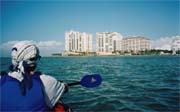
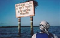
Shortly after a golden sunrise we’re
on the water. As we paddle the channel that leads to the
Caxambas Passage, we are once more flanked by mangrove-covered
shoreline, but soon a "Manatee Zone" sign and the tall
hotel buildings of Marco Island signal the end of the
wilderness. After 17 days in the Park, with only brief stops in
small settlements, the high-rises come as a shock. As we round
the tip of Marcos Island at the Caxambas Pass entrance, we
encounter choppy water because of the outgoing tide. We paddle
hard until we’re back in calmer water, passing fancy hotels
and palm-fringed beachfronts, where people jog and splash in the
water.
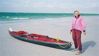
 We are hoping to be able to make it all the way to
Naples, 15 km to the north, but the wind doesn’t cooperate. By
10 a.m., a mass of bulbous cumulonimbus starts building on the
northern horizon. And then the wind switches direction. It’s
now coming from the NW. We are aware that a cold front is
forecasted, but we didn’t expect it to arrive so soon. As the
wind mounts, we scan the beach for a safe place to land and head
to shore. Minutes after our landing, the wind has turned into a
storm, topping the blue-green water with whitecaps. A woman and
her teenage son see us struggling with our boat, and they offer
to carry it to a well-tended lawn with thatch-roofed picnic
shelters, next to a refreshment stand and a fountain. But we don’t
have time to marvel at the spotless landscaping. A middle-aged
lady in prim white shorts emerges from a parking lot booth and
tells us we are not allowed to stay here because this is a
private beach. The fact that we paddled here all the way from
Key Largo, and that we will pack up the boat and leave in a few
hours, doesn’t soften her resolve. "You absolutely cannot
stay here," she asserts. So our 250-km kayak expedition
ends on a sidewalk in one of the ritziest neighborhoods in the
U.S. It felt as if civilization was claiming us back with a
vengeance. We are hoping to be able to make it all the way to
Naples, 15 km to the north, but the wind doesn’t cooperate. By
10 a.m., a mass of bulbous cumulonimbus starts building on the
northern horizon. And then the wind switches direction. It’s
now coming from the NW. We are aware that a cold front is
forecasted, but we didn’t expect it to arrive so soon. As the
wind mounts, we scan the beach for a safe place to land and head
to shore. Minutes after our landing, the wind has turned into a
storm, topping the blue-green water with whitecaps. A woman and
her teenage son see us struggling with our boat, and they offer
to carry it to a well-tended lawn with thatch-roofed picnic
shelters, next to a refreshment stand and a fountain. But we don’t
have time to marvel at the spotless landscaping. A middle-aged
lady in prim white shorts emerges from a parking lot booth and
tells us we are not allowed to stay here because this is a
private beach. The fact that we paddled here all the way from
Key Largo, and that we will pack up the boat and leave in a few
hours, doesn’t soften her resolve. "You absolutely cannot
stay here," she asserts. So our 250-km kayak expedition
ends on a sidewalk in one of the ritziest neighborhoods in the
U.S. It felt as if civilization was claiming us back with a
vengeance.
|
