|
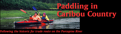
Paddling in Caribou Country:
Following the historic fur trade route on the Porcupine River
(Part I)
by Karin Herrero
|

Suddenly, our kayak picks up speed once more. Around the next bend
we hear the now familiar noise: the rushing of water. “Oh, no,” I
sigh. “When will these rapids be over?” I push the rudder pedal to
initiate a turn, but our heavily loaded folding kayak responds too
slowly, and we don’t manage to catch the main channel. With a
crunching noise the boat runs aground in swift, shallow water,
while Kurt’s kayak has already disappeared from view. I look at
Karin, hoping that she, with one previous white water experience,
can offer guidance to me, the ocean- and lake paddler. But her
nerves are as frayed as mine from the previous rapids we had to
run on the otherwise slow-moving Little Bell River. Twenty-two
years ago, Kurt and Karin had paddled the same river. When they
described the trip to me in early 2003, they didn’t mention
rapids. |
 |

High water and tight corners made for
challenging paddling on the Little Bell River. |
Karin gets out of the kayak. Barely managing to keep
her balance in the fast current, she tries to drag the boat off the gravel
bar. The sound of rocks grinding along the rubberized hull is sickening. I
just hope we don’t end up with a leak. The boat moves a little, but not in
the desired direction. Now we are broad side to the current – a dangerous
position. Our efforts to turn the boat around are futile. Another jolt
from the current now turns the stern downstream. It looks as if I and the
boat could get swept away any minute, leaving Karin behind. “Get in!” I
shout. She jumps in and the Little Bell takes us. With ever-increasing
speed we are swept down backwards, along the right side of the river,
bucking through the rapids, bumping over rocks and crashing into
overhanging willow branches.
The roller coaster ride takes only minutes. At the
bottom of the rapids, the current slows and the river spits us into an
eddy. We manage to turn the kayak around, and make the next bend without
further mishap. Relief! We are still afloat and I don’t see any water
inside the boat. A few more corners, then the green shoreline recedes, and
we glide into the wider Bell River, where Kurt and the two kids in their
double kayak are waiting in an eddy. Panic and fear drip from me like
droplets from a paddle. Relieved, but exhausted, we paddle a bit further
until we find a steep mud bank. Cold and shaken, we climb through
shoe-sucking mud to level ground and revive ourselves with a warm fire and
hot soup. These were the first, and hardest, four hours of our 20-day
paddling trip on the Bell and Porcupine Rivers.
|

Kurt and I first crossed paths in 1984, when he helped
me and my sister survive a chilly swim in Alaska’s McKinley
River. After that, we had stayed in loose contact over
the years. In early 2003, Kurt and his wife Karin invited
me to join them on their family adventure, paddling the
old Hudson’s Bay Company (HBC) Route from Summit Lake
in the Richardson Mountains at the Yukon/ NWT border,
to Fort Yukon, Alaska.
 On
this 800+ km long river journey, above the Arctic Circle,
we would follow the Little Bell River to the Bell River,
then enter the Porcupine River and paddle it all the way
to Fort Yukon, at the confluence of the Yukon River. We
would travel across the width of the Yukon Territory,
passing only one settlement, Old Crow, about half-way
through the trip. On
this 800+ km long river journey, above the Arctic Circle,
we would follow the Little Bell River to the Bell River,
then enter the Porcupine River and paddle it all the way
to Fort Yukon, at the confluence of the Yukon River. We
would travel across the width of the Yukon Territory,
passing only one settlement, Old Crow, about half-way
through the trip.
|
|

The Little Bell River from the
air. |
|
Paddling the Porcupine seems to be popular among Europeans. Before the
trip, I read the online story of a German guy who paddled the route solo a
few years ago; and a former work colleague told
me of some Swiss friends of his who had also done the trip. I was almost
expecting to run into several parties on the river, but that wasn’t the
case. Later we were told that usually one or two parties per year make the
entire trip from Summit Lake to Fort Yukon.
On August 1, we met in Whitehorse, Yukon’s capital,
from where we flew via scheduled flight to Inuvik, NWT. During a stopover
in Old Crow we got a glimpse of the area where we would travel through in
a few weeks, but the view wasn’t encouraging: low-lying clouds,
intermittent showers, and a brown, rain-swollen Porcupine River. I was
amazed at its size.
In Inuvik we stayed just long enough to get our
charter flight organized and to buy food supplies. The same evening we
flew into Summit Lake in two trips, since there wasn’t a larger float
plane available to carry all five of us and our gear. Karin, Tarim (age 8)
and I arrived at 10:30 pm at Summit Lake, where Kurt and Teja
(age 6) were already waiting in front of their tent. As soon as we stepped
onto the spongy tundra, the plane ferried away and took off. It was a
cool, calm and overcast evening and we quickly got into our tents to catch
some sleep.
|
|
|
|

Arrival at Summit Lake.
|
|
|

First evening in the wilderness: our
camp at Summit Lake.
|

Packing the gear for the portage to the Little Bell
River.
|

Assembling the folding kayaks
in the tundra.
|

Morning: Gray and purple mountains, their lower
flanks draped in willow bushes, surround us. Fog patches clear from the
summits. A slight breeze ripples the lake surface. The silence is
palpable. The nearest road is the Dempster Highway, nearly 100 km to the
southeast, across mountains, rivers, and tundra.
The kids run off to explore and excitedly tell us
they’d spotted a beaver along the lakeshore. Surrounded by piles of gear
and food supplies, we have a leisurely breakfast. But the peace is
destroyed as soon as the sun pokes through the clouds. Mosquitoes and
black flies arrive in droves! Our 1 km portage from the lake to the Little
Bell River turns into misery. Staggering through the muskeg with our heavy
loads, enveloped in a cloud of bugs, and sweating in the heat, I
experience first-hand what the voyageurs must have felt like when they
travelled this route in the mid 1800s.
|
Voyagers [sic] in the Yukon Territory
regularly paddled freight up the Rat River to a 9-mile portage over
the Richardson Mountains [McDougall Pass] then down the Bell River
to the headwaters of the Porcupine. Thirty-foot long “Yukon boats”
carried trading goods downriver past Gwich’in villages to Fort
Yukon, where beads, cloth, metal tools and trinkets were traded to
the Gwich’in for furs. It then took three and a half years for the
furs to reach London via the river and lake route to Canada’s Hudson
Bay.
(The Alaska River Guide, Karen Jettmar, Alaska Northwest
Books 1993) |
When we reach the Little Bell River, my heart sinks.
There is no shore from where we can easily launch the kayaks, only steep,
overgrown mud banks, with the dark, still waters of the river below. “How
do we get the boats down there?” I ask Kurt. He reassures me we’ll find a
solution. In the warm and muggy afternoon, swarmed by mosquitoes, we
assemble the boats. Although we are keen to get the Little Bell River
behind us as quickly as possible, we are so exhausted from the portage
that we decide to stay another night and get an early start on the river
tomorrow. In the twilight of the arctic night, I wake several times to
hear rain and to marvel at a double rainbow arching over lake and
mountains. A good omen?
In the morning, after a quick breakfast of bread and
tea, we finish packing the boats. Kurt rigs up a rope system. While he
holds the stern, I take the bowline and, one by one, we guide the boats
down the steep embankment. Luckily there are no rocks, so the keel slides
easily on wet mud and over slippery willow branches. From a foot-wide
ledge at the water’s edge, we climb into the boats and set off. The day is
damp, overcast and cool, but luckily there is no rain. Following the tight
bends of the river, we paddle steadily until we encounter the first set of
rapids.

After our scary ride on the Little Bell River, Karin and I are glad to be
on the wider Bell River, where the kayak glides effortlessly through the
dark green water. But camping along the river turns out to be a challenge.
The banks are steep and overgrown, and if there are any gravel bars, most
of them are submerged because of high water. As the afternoon wears on, it
starts drizzling. We scan the banks for possible landing spots. One bank
turns out to be treacherous muck, where we can barely extract ourselves
from, so we continue paddling. Finally we find a tiny gravel bar, barely
the length of a kayak, next to a small creek. We pull out the boats as
best we can, haul our gear through the bush and set up camp higher on the
moss and lichen-carpeted slope among stunted black spruce. Kurt manages to
coax a smoky fire from damp dead wood, but we are so tired that we cancel
our elaborate dinner plans. As another rain shower descends, we sit in the
family tent, sharing jokes and songs, and a pot of boiled sweet potatoes.
|

First camp on the Bell River: a tiny gravel bar
beside a small creek.
|

The first comfortable campsite on the
Bell River.
|

Kurt and the kids on a pleasant
morning on the Bell River.
|
The mountains recede into the distance. Now we are
hemmed in on both sides by bush: a wet, impenetrable green. In the
afternoon we reach a broad, level gravel bar, where Kurt and Karin had
camped 22 years ago. It’s the first comfortable campsite we have found on
this river so far and we’re elated. A light breeze keeps the mosquitoes in
check, and there is sufficient fire wood. Even the sun decides to appear
and we all take a quick dip in the river. “This is how wilderness camping
should be,” we tell each other, hoping that from now on we have done with
the terrible three: MOSQUITOES, MUD, and RAIN. Tarim is happy to have
found his private gym on a large patch of sand and he’s doing cartwheels
and headstands. We hang our damp clothes to dry, and I inspect the hull of
my kayak. Although the reinforcement strips are torn, the Hypalon material
isn’t ruptured. Kurt puts seam grip on the tears, and then we pack the
boats to be ready for an early start in the morning. I revel in the
thought of packing up a dry tent in the morning. But a rain shower in the
night vanquishes my hope.
After hours of paddling, we must be close to
Lapierre House (a former HBC post), but except for a clearing in the bush
above the river, we don’t see anything. Then the first rain drops hit, and
soon the rain comes pouring down, followed by a strong, cold headwind.
Despite gloves, my hands are cold, and my feet, in neoprene socks and
sandals, feel like ice cubes. Frantically, we scan the shore for a level
spot where we can get out of the water. The kids, both in Kurt’s kayak,
are hidden underneath their yellow rain ponchos. They hardly complain. I
am amazed at their toughness. Tall Kurt can’t use the spray cover because
his knees are above the gunwale. He is drenched.
|
Near Sinclair Rock, at a sharp bend in the
river, we find a gravel bar, dotted with willow bushes, and fight
against the current to reach it. In a flash, Kurt has set up the tent
and ushers the kids inside. We haul the boats out of the water and
escape from the rain. Hours pass. Nobody wants to get outside and
start dinner. When I finally poke my head out, I notice that the rain
has turned to sleet. Then I hear Kurt cursing as he braves the
elements, searching for a cooking pot and some food among the upturned
boats. Later, we all meet in the family tent and share a pot of
mushroom soup. By 9 pm the rain and wind have abated somewhat, but the
temperature plummets. Despite wearing a fleece sweater and polypro long
johns, I spend the night shivering in my light-weight down sleeping bag. |
|

Temporary shelter: the wet and cold camp near
Sinclair Rock.
|
Kurt calls me around 5 am. “You better pack up. Your
tent will be flooded within the hour!” I stick my head outside. The water
is only a few feet from my tent, and it’s still raining, although only
lightly. Kurt checks our water level markers – twigs we stuck into the
ground at the water’s edge. “The water’s been rising about 8 to 10 cm per
hour,” he reports. I stuff my soaking tent and then dive into the family
tent, a few metres farther back from the river. By 7 am we start packing
up since the water is still rising. No time for breakfast. After one
uncooked tortilla each, we launch the boats. The air is cold and damp,
with the temperature hovering around 1 or 2 °C. Compared to yesterday’s
paddle in the noisy wind and driving rain, today feels peaceful, as we
push off into the grey drizzle. After a few hours of paddling, we find a
small gravel bar and stop to build a fire. Luckily, we find some dry wood,
and with the help of some white gas, we soon have a big fire going. Warmth
seeps through my body. Feeling returns to my toes. In this cold and wet
wilderness, the fire keeps our bodies and spirits intact.
|

Building a fire on a cold morning
on the Bell River.
|

Warming up: (from left) Tarim, Teja, and the author.
|

Reaching the Porcupine River.
|

After several mugs of hot soup, we take off once more. Within half an hour
we pass the largest gravel bar yet – the best camping spot imaginable, but
we don’t want to stop so soon again, especially since the weather seems to
be improving. Upon reaching the confluence of the Eagle River, Karin and I
keep chatting and paddling, until we hear Kurt’s emergency whistle in the
distance. Worried, that something might have happened to them, we turn
around until we’re within shouting range. Kurt is bending over with
laughing. “You’re going in the wrong direction,” he chuckles, “you’re
following the Eagle River.” Chagrined, we turn around and follow his
kayak.
|
If Karin and I had continued paddling upstream
on the Eagle River, we would have come to the spot where Albert
Johnson, the “Mad Trapper of Rat River” was killed on February 17,
1932, during a shoot-out. Police had tracked him through the frozen
wilderness for weeks. Albert Johnson (as he called himself) had
appeared in Fort McPherson on the Peel River the year before. He had
moved into the Rat River district
to trap, but started interfering with the trap lines of the Indians
there. A complaint brought the police to his door. Refusing to talk,
and without any warning, he shot one of the police officers through
the door. A search warrant was issued and a posse, consisting of
several officers and trappers, was sent out to arrest him. In
sub-zero temperatures, Johnson led them on a mad chase through the
wilderness, often wearing his snowshoes backwards to confuse his
pursuers. During several encounters with them, Johnson gravely
wounded two other men, and then fled over the Richardson Mountains
during a blizzard, crossing a mountain pass said to be impenetrable
in the winter. This arctic man-hunt, and the final shoot-out on the
Eagle River, fuelled the imagination of the media in the years
during the Depression. But despite numerous further investigations,
the mystery surrounding Albert Johnson’s identity was never
resolved. |
The rain has left its legacy: the bush is dripping
wet, and rivulets run from every river bank. But the weather is looking
up. The sky is revealing patches of blue, fringed by white puffy clouds.
Yesterdays’ storm is spent.

We have now settled into our river routine: Kurt is first up in the
morning, getting the fire and breakfast going, while Karin and I pack up
the tents. During the day, we stop about every two hours for a quick
break, averaging 5 to 6 hours of paddling per day. In the evenings, Kurt
builds a fire and we take turns making dinner.
Mist rises from the river and evaporates into a blue
sky – the first real sunny morning since we started the trip. But
the river is still rising: our gravel bar is under water. Luckily we had
put the tents higher up onto a grassy ledge. Within two hours’ of
paddling, we reach the Porcupine River.
What a mighty river! The shoreline is hundreds of metres away in both
directions. Now, crossing from one side to the other to catch a faster
current or to hide from the wind, will require lots of paddling. At the
confluence, among birch and spruce trees (the first birches we’ve seen on
this trip) we spot a cabin on the river bank – the first signs of human
presence since we left Summit Lake, but no one answers our calls. With
some tail wind, Karin and I manage to do a bit of sailing with our large
golf umbrella – a welcome respite from paddling, especially since I got
hit by a nasty cold that has me in coughing fits throughout many sleepless
nights. But, it feels good to have reached the Porcupine River, our main
objective on this trip. From now on, finding a good camping spot isn’t a
challenge anymore – gravel bars are numerous, and they get bigger as the
river increases in size.

A clear morning! A vast, cloudless sky arches over bush and river. We’re
on the water by 8 am, gliding through the still waters, only occasionally
rippled by a breath of wind. This is a day when I fully appreciate being
here. Before the trip, I had envisioned how it would be, following the
river, living along its shore, and tuning in to nature’s rhythm. But so
far, the trip has felt more like being on the run from bad weather and
bugs. Mornings like this put everything back into perspective.
|

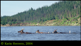
Near the confluence of the Driftwood River, we spot
the first caribou.
|

The mighty Porcupine River is no obstacle to the
caribou.
|

Drifting in our kayak, we can observe
the caribou at close range.
|
Suddenly we glimpse several moving objects on the
right shore. Paddling closer, we realize they are caribou – four adults
and one baby, the forerunners of the mighty Porcupine Caribou herd, moving
south from the Arctic coast. The next day, past the confluence of the
Driftwood River, we see groups of up to 30 animals, feeding along the
shore. Then they plunge into the river and swim across, with only their
heads and tails sticking out of the water. Kurt tries to get closer, but
he isn’t prepared for the speed these animals are traveling at. When he
reaches the middle of the river, they are already across, standing on a
mud bank, shaking the water out of their hides.
|
The Porcupine Caribou herd, named for the
river on which we paddled, has been moving across the arctic
lands of Alaska, the Yukon, and the Northwest Territories for more
than 20,000 years. Twice a year, the herd migrates more than 700
miles to and from its traditional calving grounds in the Arctic
National Wildlife Refuge (ANWR), on the arctic coastal plain of
Alaska. In the winter, the caribou move to the southern portion of
their home range, where they are an important resource for the
Gwitchin people.
Whereas some areas within the Refuge have been protected from human
development, the calving grounds are unprotected. Now, strong
pro-development forces within the US government want to open oil and
gas exploration in and adjacent to the calving grounds, threatening
the survival of the Porcupine caribou herd, the ecological integrity
of the Refuge, and the life-ways of the local people. |
Click
PART II to continue the story

|